Details: |
What materials were used in making this project?
Pencils, sketchbook, cardboard and scissors (shield templates), painter's canvas floor tarp, eight colors of exterior latex paint, disposable drop cloth (thin plastic to protect tables and other supports), disposable cups, plastic spoons and bamboo skewers (mixing and stirring), paint brushes of various sizes, extra heavy canvas scraps and needle and thread. Several sizes of Sharpies
|
What are the project's measurements?
12 ft by 9 ft
|
What kind of construction methods or techniques were used?
Early studies were done with pencil and sketchbook. Outline sketches were made on a painter's floor tarp with a carpenter's pencil. Several sizes of paintbrushes up to 3 inch width were used to paint combinations of eight colors of exterior latex paint diluted 50/50 with water in disposable cups per class notes by Mistress Rochwen of Calontir for painted floor tarps. The wall hanging used less paint than a floor tarp due to weight considerations and the planned usage not needing the waterproofing the thicker application of paint would give. Loops were sewn along the top back boarder to assist mounting as a wall hanging. A background in color theory is useful for the selection and mixing of the colors. Knowledge and research into the various subject elements is helpful both in the creation and enjoyment of the project.
|
Was the project based on a specific time or culture?
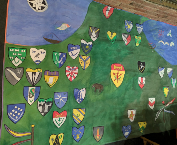
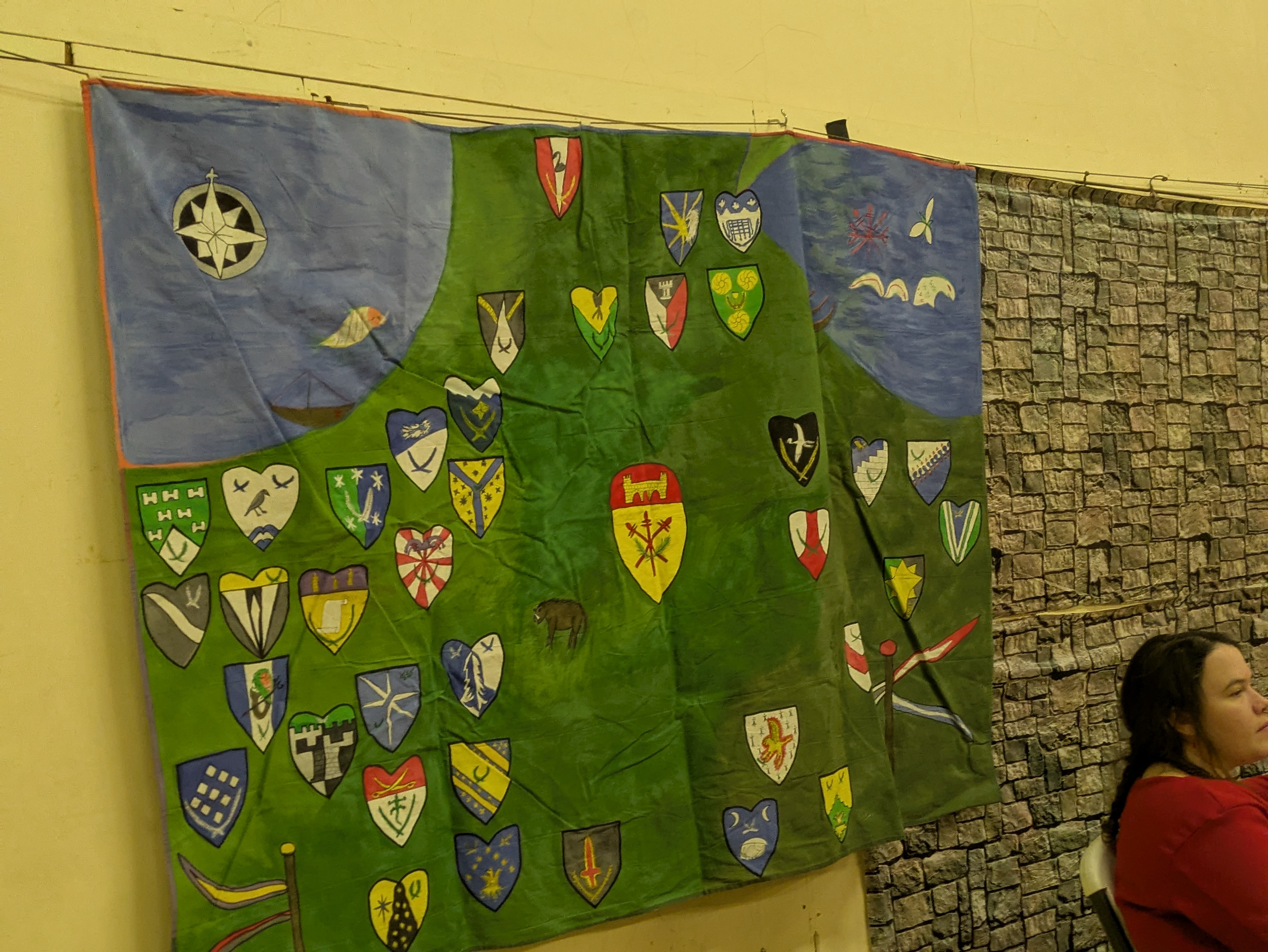
This wall map was based on European wall maps, specifically the Ebstorf Mappa Mundi (1235 CE) which was painted on 30 goat skins and measured 12 ft by 12 ft. The content was selected based on the history of the Midrealm and the Barony of Red Spears.
|
Were any modern materials or methods used? If so, what led to that decision?
Canvas was used instead of hides due to weight and portability considerations. The 12x9 foot commercially produced canvas tarp was selected based on the ultimate usage where a 12x12 square or larger painter's tarp was thought to be too large for the space. Latex exterior paint was chosen due to it's elastic quality surviving folding and reuse without cracking.
|
Was there a specific reaction or emotional response you wanted to cause in the viewer/audience? If so, how did you hope to achieve it?
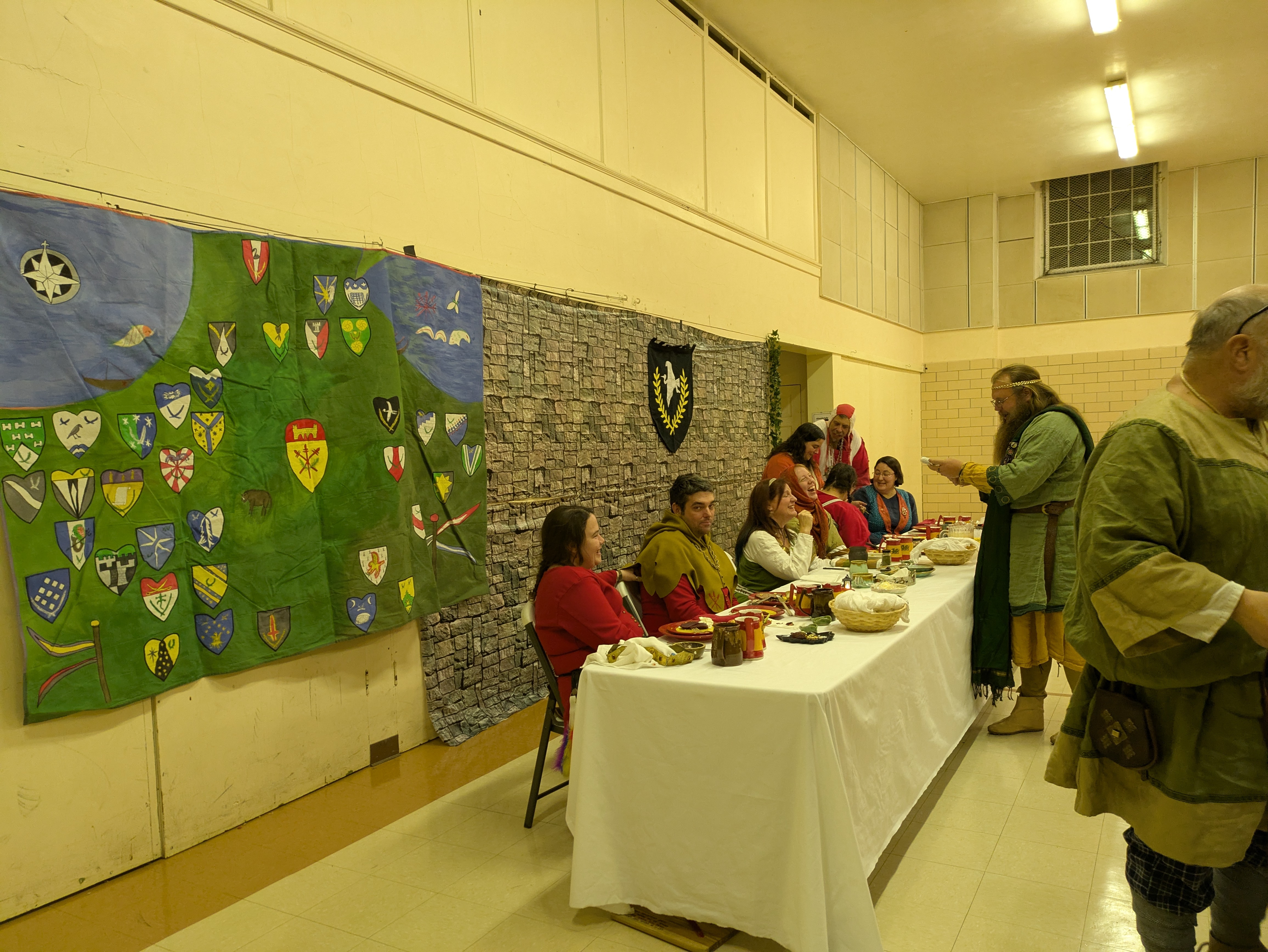
The specific reaction or emotional response desired was a combination of curiosity, 'oh pretty', 'wow!', and amusement due to the size, colors, and subject matter. The two public displays and many in-process working days succeeded in garnering those reactions.
|
Describe the process you went through in making the project.
Several weeks were spent on collecting the currently active baronial and shire heraldry and doing practice sketches of all the chosen elements while working on placement scaled down to a large sketchbook. After acquiring materials, sketching the rough layout using the templates, and later filling in details, the painting commenced in small sections starting with the background and continuing with a few colors each painting session. Outlines and some details were finished with sharpies. Elements related to Red Spears occupy several otherwise empty areas such as the traditional Baronesses� ships on the lake shores, and boar in the farmlands. The Lake Erie sea monster Bessie is depicted as an ice dragon swimming over to the Barony of Ryddrich Hael, Aethelmearc (not shown). The Boar Whale of Lake Michigan walks up the shallows along the beaches. Sharpies are an important element, recalling a storied embroidery technique.
|
What did you learn while working on this project?
The technique I used of painting directly on the canvas shows color variation and brush strokes in ways that are difficult to hide. I was able to use this to my advantage to give a rough indication of terrain but it is something to be aware of if using this technique for large areas of color.
|
If you were to make this project again, what would you do differently?
- The next wall hanging will be a similar size but based on a 10x10 ft Roman floor mosaic found in London in 2022. The hope is to make it easier for more people painting at construction sessions by using a simpler color scheme and broader shapes.
- Iron before painting: Mistress Rochwen recommends ironing the canvas before starting the painting and I did not do that for this project. Folding instead of rolling the canvas for storage left wrinkles that did not go away while hung up on a wall all day.
|
Were there any surprises?
A 1 inch brush is amazingly versatile. I was informed while making this that hearts are acceptable for heraldic display so I used them for the shire and canton heraldry. After drafting the escutcheon for the baronies, I discovered that the width at the straight top was also the perfect height from the bottom tip for the inner point of the heart generally leaving enough room for the group heraldic elements.
|
Were there differences between what you set out to do and what you eventually did? How and why did the plan change?
12 ft by 9 ft is a large space. The original plan was to only include baronies and the active Red Spears cantons. That expanded to include the shires once it was determined that I was going to squish perspective anyway, and the relative locations including shires fit well. A few elements of Red Spears History may be added in the future which were not included yet due to focus and time constraints.
|
What inspired you to create this project?
This wall hanging was created at the request of Baron Leofric, Baron Red Spears, who desires more wall coverings for the winter event hall.
|
How would you sum up this project and your experiences in making this?
Lots of work but definitely would try this again. There is plenty of room to continue tweaking and refining several elements in this painting.
|
Anything else you'd like to say?
Artists Statement: As a commission by the Baron of Red Spears, baronial and active cantons are depicted in the center of map. Baronies use a regular escutcheon shape, while active shires have hearts. Inspiration by the �SCA 101: Meet the Neighbors� article in the Barony of Red Spears Spearpoint newsletter grew to include the neighboring kingdoms. Former Midrealm regions Calontir, Ealdormere and Northshield are given enhanced visibility with the purple border on the western edge for Calontir, north-star emblem of Northshield and cheddar curtain border, trillium of Ealdormere and red border. The green border represents the Debatable Lands. Shades of green background roughly follow the landscape with darker green for mountains and lighter green for grasslands. Blue border for Atlantia. Black border for the old Ansteorra boundary. Banners host colors for the kingdoms of Glenn Abhann and Calontir in the southwest, and for Aethelmearc, Atlantia, and Meridies in the southeast.
|
Links: |

17th century shipwreck of Le Griffon: Explorers dive into Lake Michigan to identify shipwreck site
https://upnorthlive.com/news/local/explorers-dive-into-lake-michigan-to-identify-shipwreck-site
News of the 17th century shipwreck of Le Griffon, the first European ship to travel the Great Lakes which sunk in 1679:
|
A Wall Map of the Midrealm Write-up for the BSWG 2 event
https://docs.google.com/document/d/1FbTgGLiKEYPsHMgBNbVwKVGDMv9MZeUkMW_fhc7dTvM/edit?usp=sharing
An early version of this project. The write up includes a brief history of the use of maps as wall hangings. Some decorative elements of the map such as the Boar Whale are documented to their earliest known sources. In progress photos are includes of the construction.
|
Answer Key: Heraldry on the Map of the Midrealm Wall Hanging
https://drive.google.com/file/d/1cB0MBho4AyAbYHp5DqZ_YJyd-DAopSVj/view?usp=sharing
Group names for the depicted heraldry on the Map of the Midrealm Wall Hanging for groups active in 2024, A S. LIX
|
Ebstorf Map
https://en.wikipedia.org/wiki/Ebstorf_Map
The Ebstorf Map was an example of a medieval European map of the world: a mappa mundi. It was made by Gervase of Ebstorf some time between 1234 and 1240 by painting on 30 goatskins sewn together and measuring around 12 ft � 12 ft (3.6 by 3.6 meters). It survived in a convent until 1843 and the original was destroyed in the 1943 bombing of Hanover.
|
Ebstorf Map: Image
https://en.wikipedia.org/wiki/Ebstorf_Map#/media/File:Ebstorfer_Weltkarte_2.jpg
Photo of a reproduction of the Ebstorf Map. Note east is at the top.
|
Lake Michigan Whale Watching
http://lakemichiganwhales.com/
A joke promotion for boat tours that ran over several web platforms from 2002 to 2017.
|
Lake Michigan: Set Sail in Search of Great Lakes Whales
https://www.chicagotribune.com/1985/06/07/set-sail-in-search-of-great-lakes-whales/
A 1985 Chicago Tribute article updated in 2021 on the history of sightings and boat tours for Great Lakes Whale Watching. May be behind a paywall.
|
Lake Michigan: Truth and myths about the Great Lakes
https://www.lansingcitypulse.com/stories/truth-and-myths-about-the-great-lakes-fact-or-fake,56074
Promotional article for the book �The Great Lakes: Fact or Fake,� by Dave Dempsey.
|
Maps: Early_world_maps
https://en.wikipedia.org/wiki/Early_world_maps
A general article on the type and varieties of maps of the world throughout recorded history with many links for further research
|
Maps: The Shape of the World by Iman Ghosh
https://www.weforum.org/stories/2019/07/the-shape-of-the-world-according-to-old-maps/
Maps have been made for millennia. For a quick list of maps through the centuries this article from Jul 22, 2019, lists many famous maps with key details and images of the originals or reconstructions where the original no longer exists.
|
Sea Boar: Carta Marina
https://en.wikipedia.org/wiki/Carta_marina
Carta marina et descriptio septentrionalium terrarum (Latin for Marine map and description of the Northern lands; commonly abbreviated Carta marina) is the first map of the Nordic countries to give details and place names, created by Swedish ecclesiastic Olaus Magnus and initially published in 1539. The map contains depictions of many types of whales and sea creatures, some fantastical or based on legends. An early depiction of "Aper Marinus Cetaceus"
|
Sea Boar: Carta Marina: Image
https://en.wikipedia.org/wiki/Carta_marina#/media/File:Carta_Marina.jpeg
A public domain image jpeg of the Carta Marina: Carta marina et descriptio septemtrionalium terrarum ac mirabilium rerum in eis contentarum diligentissime elaborata anno dni 1539. The boar whale is depicted in the top row center section of the map.
|
Vlyssis Aldrouandi Patricii Bononiensis Monstrorum historia cum Paralipomenis historiae omnium anima
https://books.google.com/books?id=9c0WtJUZcC4C&newbks=1&newbks_redir=0&dq=Vlyssis%20Aldrovandi%20pat
Appendix: Parallel notes (Paraliponena Historiae Omnium Animalium) page 63 "Aper Marinus Cetaceus" from Ulysses Aldrovandi's 'History of Monsters' 1642. Another depiction of "Aper Marinus Cetaceus"
|
Sources: |
| - | , "Lake Michigan Whale Watching" (2017), trans: http://lakemichiganwhales.com/ |
|
| - | Iman Ghosh, The World Economic Forum: Geo-Economics and Politics, "The Shape of the World", This article is published in collaboration with Visual Capitalist. (2019), trans: https://www.weforum.org/stories/2019/07/the-shape-of-the-world-according-to-old-maps/ |
|
| - | Mistress Rochwen Mowenna of Calontir, Painted Floorcloths, Barony of Three Rivers: Self (2024), 12 |
|
| - | Nathan Edwards, upnorthlive.com, "Explorers Dive Into Lake Michigan To Identify Shipwreck Site", Northern Michigan: upnorthlive.com (2015), trans: https://upnorthlive.com/news/local/explorers-dive-into-lake-michigan-to-identify-shipwreck-site |
|
| - | Olaus Magnus, Carta marina et descriptio septemtrionalium terrarum ac mirabilium rerum in eis contentarum diligent, Rome: Pope Paul III (1539), trans: https://en.wikipedia.org/wiki/Carta_marina |
|
| - | Staff Writer, Lansing City Pulse, "Truth and myths about the Great Lakes", Lansing, Michigan: (2023), May 25, 2023, trans: https://www.lansingcitypulse.com/stories/truth-and-myths-about-the-great-lakes-fact-or-fake,56074 |
|
| - | Various authors, MiddleWiki, "Baronies" (2024), trans: https://middlewiki.midrealm.org/index.php/Baronies |
|
| - | Wikipedia, "Early_world_maps" (2024), trans: https://en.wikipedia.org/wiki/Early_world_maps |
|